Geographic Information Services
SummitWest’s GIS mapping for environmental projects provides high resolution maps and reports.
Unlock the Power of GIS Mapping for Environmental Projects
At SummitWest, we recognize the pivotal role Geographic Information Services (GIS) plays in every aspect of environmental work. With over 35 combined years of specialized expertise, our team is primed to leverage the full potential of GIS technology to propel your projects to new heights.
From spatial analysis and data integration to environmental planning and impact assessment, our GIS services deliver actionable insights and comprehensive solutions. Our adept professionals combine powerful spatial tools with in-depth knowledge, enabling us to use data to optimize environmental decision-making. SummitWest provides the GIS, remote sensing, and drone services necessary to provide high resolution natural resource maps and reports.
We provide unparalleled expertise, dedication, and commitment to delivering superior GIS services tailored to your specific environmental needs.
SummitWest’s in-house team of GIS specialists analyze field data, produce high-quality resource maps and tailor outputs to our clients’ needs. SummitWest works with ESRI, ArcGIS, and QGIS, sourcing Landsat and other highly quality natural resource and climate databases to produce contextualized, predictive, and informative maps. We produce the maps our clients want, submitting high resolution data as geodatabases, shapefiles, kmzs, resource maps, attribute tables, and georeferenced figures. SummitWest’s GIS professionals are able to share and receive GIS information electronically and on any platform.
Along with industry standard site reconnaissance and habitat assessment techniques, our team employs drones to perform large-landscape assessment and resource mapping with fine precision, imaging, and GIS data collection. Our drone program allows for natural resource mapping across rugged terrains and within narrow timeframes and tight budgets.
GIS MAPPING FOR ENVIRONmeNTAL PROJECTS:
SummitWest is skilled in the following GIS services:
- Spatial Analysis & Impact Analysis
- Resource Mapping
- Natural Resource Mapping
- Water Resource Mapping
- Field Data Analysis
- Remote Sensing
- Attribute Tables
- Georeferenced Figures
- Data Integration & Database Creation
- Environmental Planning
- Environmental Impact Assessment
- Emergency Response and Risk Assessment
- Climate Change Modeling
- Wildfire Risk
- Sub-Meter GPS Mapping
- Stakeholder Communication
- Drone Imagery Services
GIS for environmental projects is a powerful tool that allows us to efficiently analyze, manage, and communicate spatial data, supporting informed decision-making, environmental planning, impact assessment, risk management, and effective stakeholder engagement.
GIS refers to the technology and methods used to capture, store, analyze, manage, and visualize spatial data. It involves working with data that has a geographic or spatial component.
GIS allows for the integration and analysis of spatially referenced data to understand geographic relationships, and trends. With the application of GIS, users can overlay different layers of spatial information to model and map exciting underlying patterns.
GIS Mapping for Environmental Projects services:
Spatial Analysis & Impact Analysis
We leverage our expertise in spatial analysis to gain valuable insights into your environmental data. Our team specializes in analyzing and visualizing spatial information, including land cover, topography, hydrology, wildlife habitat, and vegetation. By overlaying multiple layers of data, we identify patterns, relationships, and trends that inform decision-making and environmental assessments. These spatial analyses are crucial for generating environmental impact assessments, allowing our clients to make data-informed decisions.
Resource Mapping
Natural Resource Mapping
SummitWest excels in providing comprehensive natural resource mapping services to our esteemed clients. Our expertise spans various domains, including Site and Habitat Assessments, Endangered Species and Rare Plant Mapping, Vegetation Mapping, and other resource mapping needs. We pride ourselves on our competence in developing accurate base layers and conducting meticulous post-field data processing. This meticulous approach ensures that our clients receive the highest-quality products, tailored to meet their specific requirements.
Water Resource Mapping
At SummitWest, our team of water experts and delineation specialists collaborates seamlessly with our GIS department to deliver precise mapping of water resources, even in intricate desert and arid systems. With our expertise and attention to detail, you can trust that your project is in capable hands, mitigating the risks of agency rejections. We prioritize accuracy and compliance, ensuring that our mapping services align with regulatory requirements. From assessing water availability to delineating water bodies and understanding hydrological patterns, our integrated approach combines specialized knowledge and cutting-edge technology to provide accurate, reliable, and compliant water mapping services.
Data Integration & Database Creation
Our GIS experts are skilled in merging and analyzing diverse datasets and maximizing results, including satellite imagery, aerial photographs, GPS data, and environmental monitoring. By integrating these sources, we provide a comprehensive understanding of environmental conditions, enabling informed decision-making.
Environmental Planning
We ensure effective environmental planning and management with our GIS capabilities. Our team utilizes GIS to identify optimal locations for infrastructure development, conservation areas, renewable energy projects, and other land use decisions. By analyzing environmental factors and constraints, we optimize planning processes while minimizing potential environmental impacts.
Environmental Impact Assessment
Assess the environmental impact of your project with our specialized GIS services. We employ GIS tools to analyze and visualize potential effects on sensitive habitats, wildlife corridors, water resources, and other environmental features. This enables us to identify areas requiring special attention and develop effective mitigation strategies.
Emergency Response and Risk Assessment
Mitigate environmental risks and enhance emergency response planning with the help of SummitWest’s GIS expertise. We use GIS to map and analyze hazards, such as flood, wildfire, and other natural disasters, pollution incidents, and potential environmental risks. By assessing vulnerabilities and determining evacuation routes, we help develop robust contingency plans for effective risk management.
Climate Change Modeling
Our specialized team utilizes advanced GIS technology to develop and implement climate change modeling solutions. By integrating climate data with topographic and land cover information, along with other relevant datasets, we generate accurate projections and scenarios that help organizations plan for a changing future. This includes proactive planning to anticipate and adapt to the impacts of climate change such as changes in ecosystems, water resources, and land use patterns, as well as to develop climate risk assessments and policy By integrating GIS-derived information into policy frameworks, we help you produce nature based adaptive solutions that promote sustainability, and enhance resilience at local, regional, and global scales.
To read more about our Climate Change Department, please visit this page
Wildfire Risk
In the face of escalating wildfire events, SummitWest harnesses the potential of GIS technology to assess, analyze, and mitigate wildfire risks, protecting communities and preserving valuable ecosystems. From risk mapping and analysis to integrating diverse datasets, such as vegetation types, weather patterns, historical fire data, predictive climate data, topography, and infrastructure locations, we generate comprehensive risk maps. We also develop effective fuel management strategies using GIS-based tools such as prescribed burns, vegetation thinning, and strategic fuel breaks to mitigate wildfire risks and enhance ecosystem resilience.
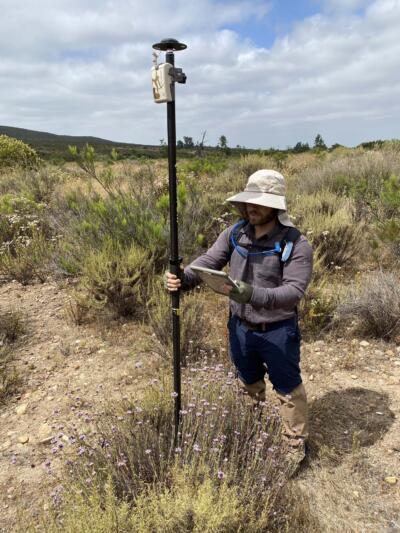
Sub-Meter GPS Mapping
Certain projects may necessitate sub-meter GPS mapping, and while anyone can rent a Trimble device to carry out the field mapping, what many may overlook is the importance of proper data processing on the backend to maintain the integrity of this highly accurate mapping. Our team of experts specializes in precisely that – ensuring that your project remains in full compliance with mapping regulations and requirements.
Stakeholder Communication
Effectively communicate complex environmental information to stakeholders with our GIS-driven communication tools. We create compelling visualizations, maps, and interactive applications that convey environmental data, analysis results, and proposed solutions. By promoting understanding and engagement, we facilitate productive communication with clients, regulatory agencies, and the public.
Tools we use
- ESRI products, such as ArcGIS, Field Maps, Survey123
- QGIS
- StoryMaps
Choose SummitWest for comprehensive GIS services that unlock the full potential of your environmental projects. Our expertise and commitment to delivering exceptional results will ensure your success in environmental analysis, planning, and decision-making.
Drone Mapping
SummitWest has two licensed drone pilots on staff and can perform drone monitoring and mapping services (see our Windswept Cranberry Bog Monitoring Project here) .
By combining drones with GIS, our clients benefit from enhanced data collection, analysis, visualization, and decision-making capabilities. Drones enable efficient and cost-effective data acquisition, while GIS provides the framework for processing, analyzing, and integrating the collected data into meaningful spatial information. To learn more about our drone mapping services please visit the Drone Mapping Services page